Setting up QGIS
This section sets up QGIS for the hazard assessment exercises. We will install Q–LavHA, a model for the probabilistic hazard assessment of lava flows working as a QGIS plugin.
Objectives
This section provides instructions on how to:
- Configure
QGIS. - Load the necessary data in
QGIS.
Installing QGIS
Download the relevant QGIS version for your own operating system from this page.
Warning
QGIS should already be installed on the computers in the lab. It should only be installed if you are planning on following the exercise on your own laptop.
Starting QGIS
- Search for
QGIS 3.2xand start it. Depending on the computer, the version might vary between3.20and3.23. Please take the most advanced one.
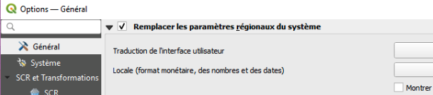
Change the language
As QGIS will most likely be in French, let's change it to English:
- From the Menu Bar, choose
Préférences>Options>Général - Change the Langue de l'interface graphique to English (Fig. 1)
- Close and restart
QGIS
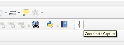
Activate the Coordinate Capture Tool
Coordinate Capture
If the tool is not available, we can manage without.
The Coordinate Capture allows to capture the coordinates when clicking on the map canvas, which will be useful throughout the exercices.
First install it: From the Menu bar, use the Plugins > Manage and Install Plugins tool and search for the Coordinate Capture tool and install it. The logo shown in Figure 2 should now appear in the Toolbar
zip -r Exercise_VolcanicRisk2023.zip Exercise_VolcanicRisk2023 -x '/.*' -x '/__MACOSX'